
Oil and Gas Expansion Threats to Tropical Forests and the Global Call for Fossil Free Exclusion Zones
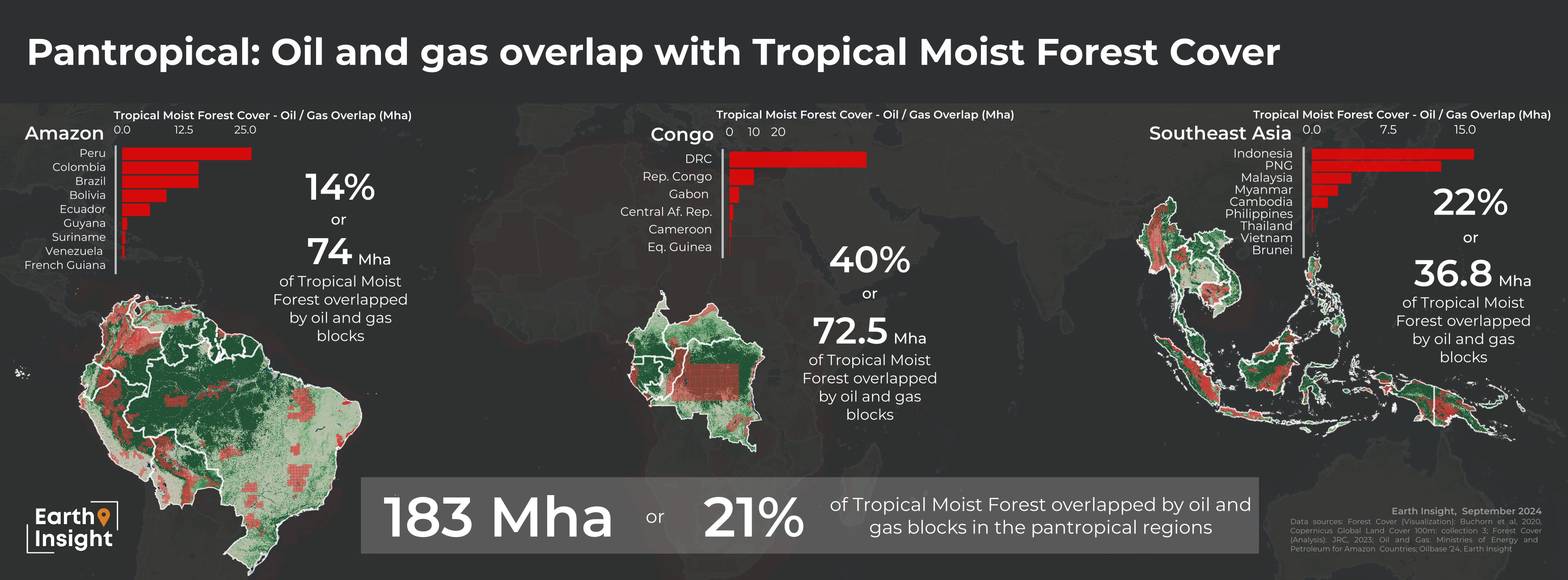
Oil and gas expansion threatens more than 180 million hectares (~450 million acres) of tropical forests in the Amazon, Congo region, and Southeast Asia.
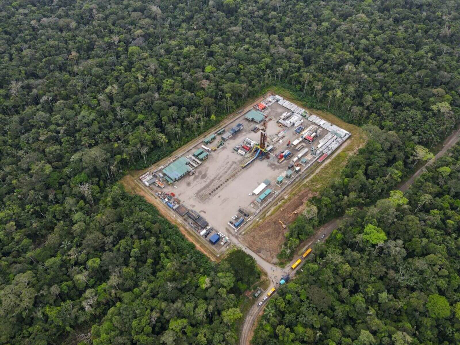
Fossil fuel expansion is most often a gateway to deforestation, as oil and gas roads built in intact forests are often the ‘first cut’ that leads to deforestation that spreads as far as 10km away. It also harms the health of Indigenous Peoples and local communities in close proximity by polluting rivers with spills and the air from gas flaring. The removal of oil and gas blocks and other extractive concessions is essential to ensure the integrity of tropical forests.
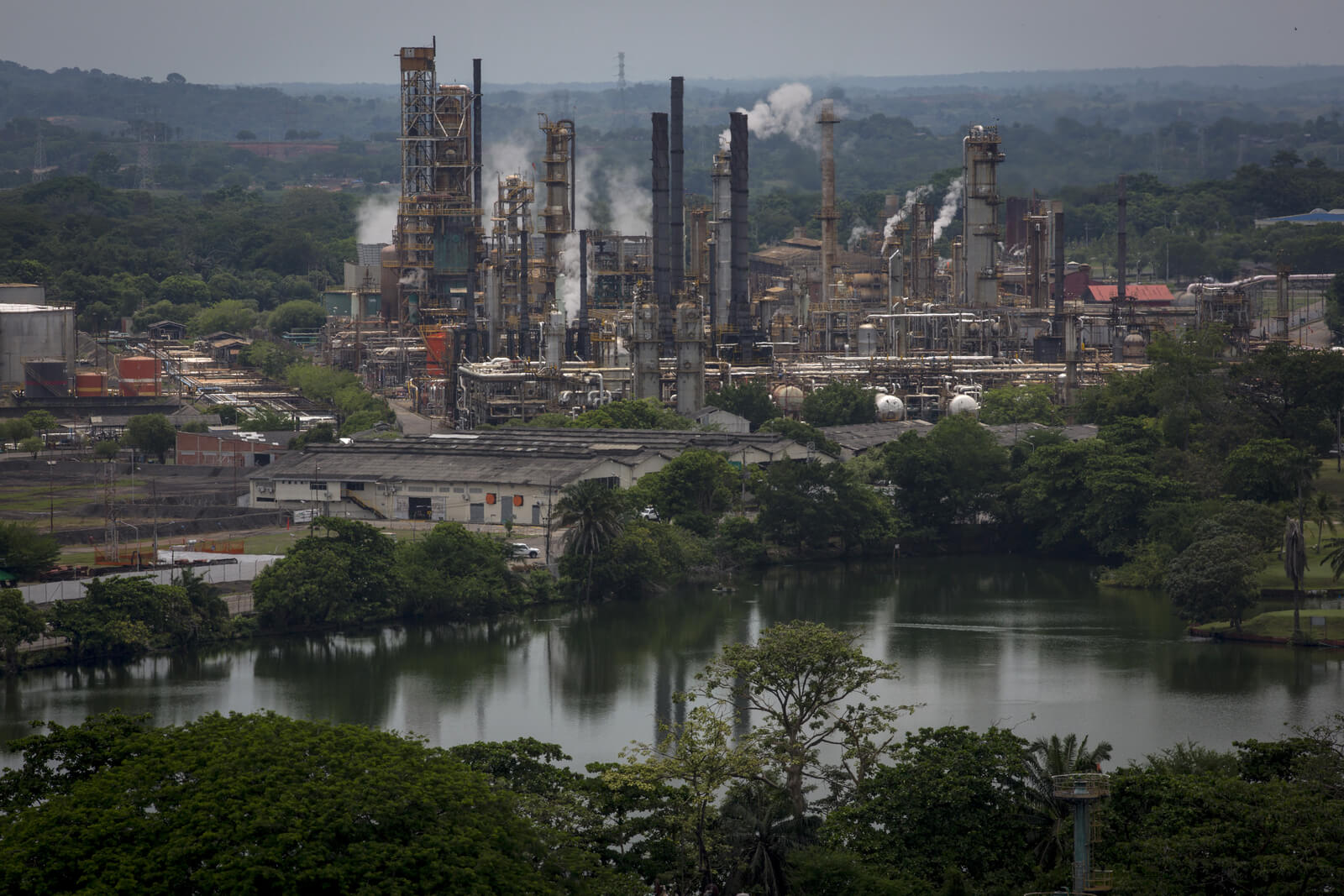
A refinery in Barrancabermeja, Santander, Colombia. Image credit: Nicolo Filippo Rosso/Bloomberg via Getty Images
A Push For Fossil Free Exclusion Zones in Vital Ecosystems
There is growing momentum for fossil-free exclusion zones around the world. In the Amazon, the Parliamentarians for a Fossil Free Future have finalized a formal inquiry on the progress of phasing out fossil fuels in the region and have introduced bills in Brazil, Colombia, Peru, and Ecuador to ban fossil fuel expansion. Led by Indigenous Peoples platforms and civil society organizations, momentum for fossil fuel exclusion zones has grown into other regions. Countries participating in the 2025 IUCN World Conservation Congress recently extended their endorsement of a fossil-free Amazon to the Congo basin to prevent catastrophic tipping points. IUCN member countries also requested its Director General and the World Commission on Environmental Law to assess policies that address fossil fuel extraction, including a Fossil Fuel Non-Proliferation Treaty.
What’s at Stake Across the Three Largest Tropical Forest Regions
By analyzing oil and gas block designations at varying country levels in tropical forest regions in the Amazon, Congo, and Southeast Asia, we found that:
- 183 million hectares (21%) of high-integrity tropical forests are overlapped by oil and gas blocks
Colombia as a Global Reference Point: A First Mover Fossil Free Phase Out
In September 2025, Colombian Environment Minister Irene Vélez unveiled a new instrument to declare the Amazon as a Renewable Natural Resources Zone, currently under consultation. Its immediate consequence is to prohibit the expansion of oil and mineral extraction in the region. According to Earth Insight's analysis, the measure will immediately protect at least 13 million hectares, more than 25% of the Amazon region in Colombia, covered by yet unlicensed oil blocks. It also upholds the rights of nearly 70% of Indigenous Peoples, Afro-descendant, and local communities threatened by the prospects of oil expansion in the region.

Aerial panoramic view of the Cerros de Mavicure in Guanía, Colombia. Image credit: Shutterstock
After upholding a de facto moratorium on new fossil fuel licenses in Colombia, this new ministerial instrument is a decisive step in the country’s transition away from fossil fuels and positions Colombia as an international flagbearer of a just energy transition centered on people, nature, and climate, setting a benchmark for other global champions. As more countries follow Colombia’s lead, the fossil fuel expansion threat to forests and the climate will begin to diminish in ecosystems that are vital for Indigenous Peoples and the climate and biodiversity crises we face.
Amazon Basin Countries
The Amazon is in the midst of a tipping point crisis. To the extent that extractive industry expansion pressures are halted, this may shift the current trajectory. At present:
- 74 million hectares, or 14% of high-integrity forests in Amazon countries, are overlapped by oil and gas blocks

Congo Basin Countries
With Africa losing 3.9 million hectares of forest annually, the stakes for nature, climate, and the millions who depend on these ecosystems have never been higher. A recent IUCN tipping point motion just affirmed the need to keep forests at 74% intactness levels in the Congo Basin.
%20(1).jpg)
Aerial view of peatland forest at Lokolama/Penzele around Mbandaka, Democratic Republic of the Congo. Image credit: Courtesy of Daniel Beltra via Greenpeace
Alarmingly,
- 72.5 million hectares, or 40% of high-integrity forests in Congo region countries, are overlapped by oil and gas blocks
- 38% of community forests are also overlapped by oil and gas blocks
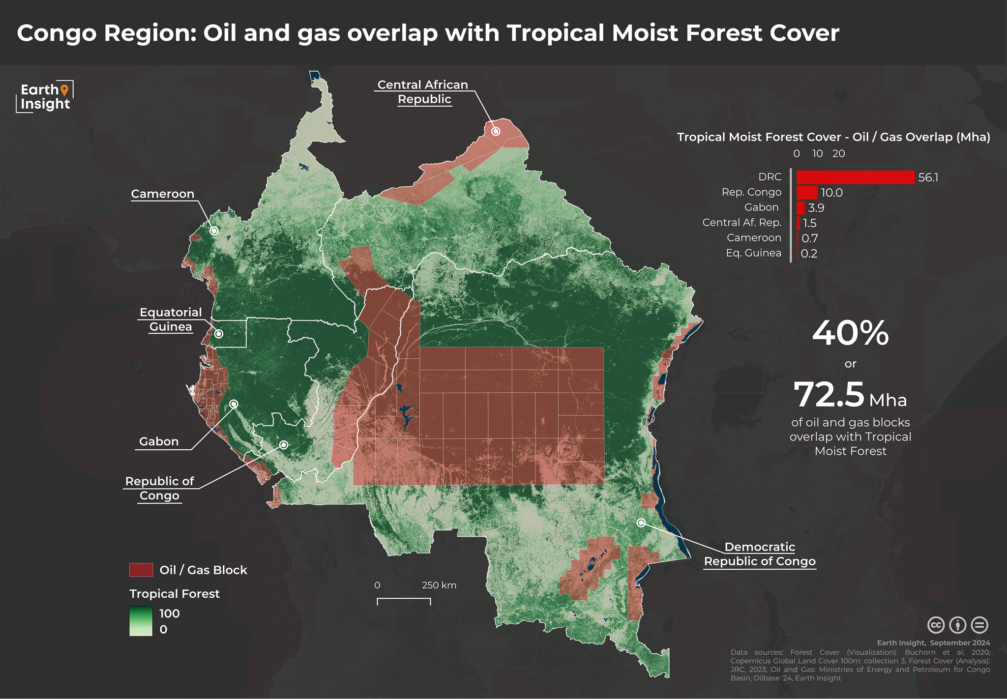
*Note: recent oil and gas block auctions in the DRC increases the total overlap area
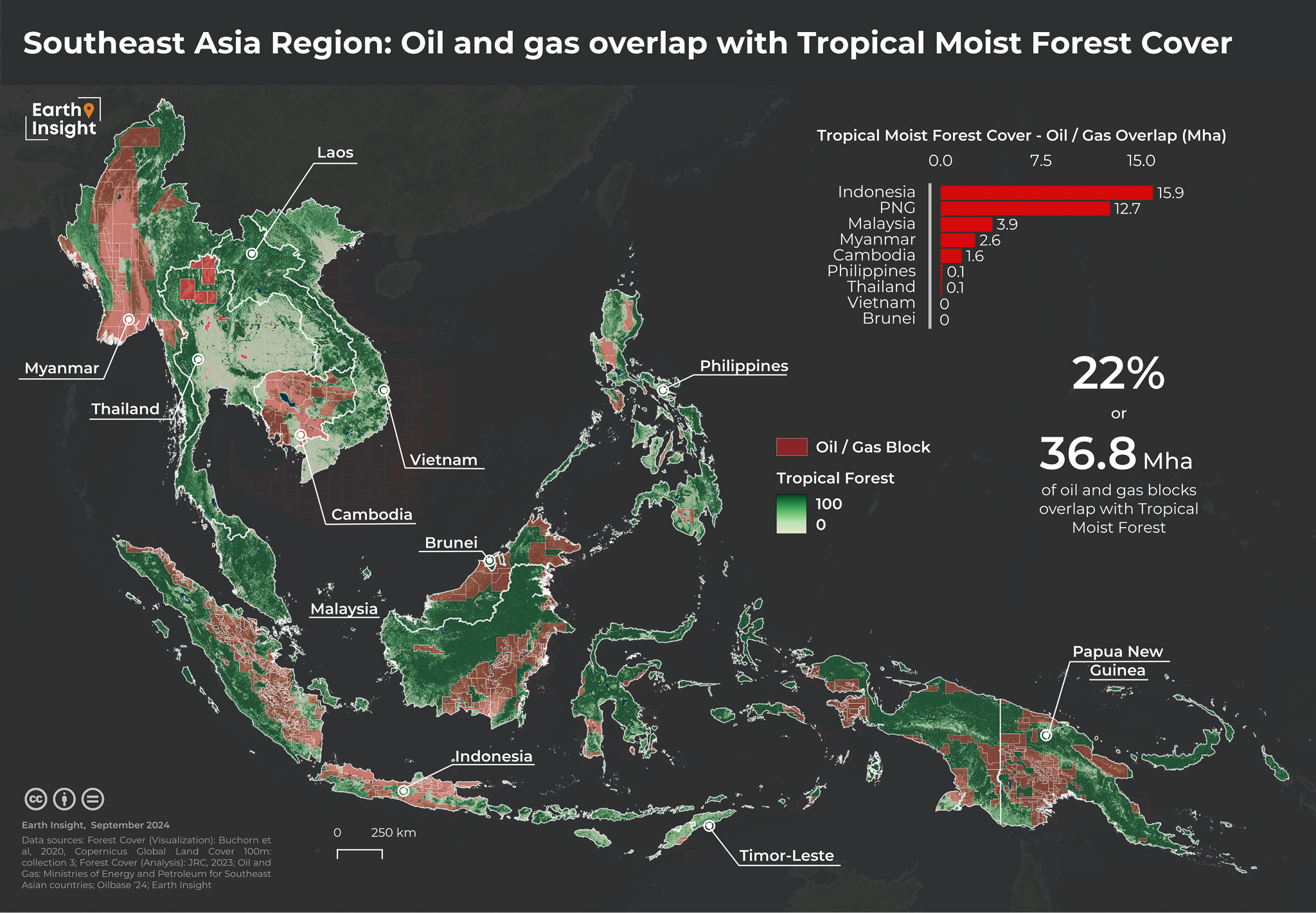
Southeast Asia
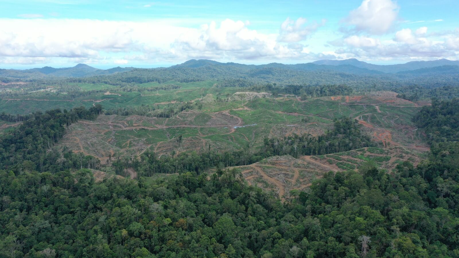
Aerial deforestation of Indonesia. Image credit: Courtesy of Auriga
The region faces widespread deforestation from the expansion of extractive activities, with 14% of Key Biodiversity Areas currently overlapped by oil and gas blocks.
- 36.8 million hectares, or almost 37% of high-integrity forests in the region, are overlapped by oil and gas blocks
High-Integrity Forests and Indigenous Peoples’ Territories
Aerial picture of the Ishpingo oil platform in Yasuni National Park, northeastern Ecuador. Image credit: Rodrigo Buendia via AFP/Getty Images
Indigenous Peoples and local communities play a vital role in protecting forests and nature. Unfortunately, Indigenous Peoples’ territories and local communities’ lands are also in peril, and many communities face violence in connection with the expansion of oil and gas and other extractive industries. In fact, a new report from the Global Alliance of Territorial Communities and Earth Insight,focused on the Amazon found 31 million hectares, or 12%, of Indigenous Peoples’ territories and local community lands in the Amazon are overlapped by oil and gas block
.png)
Oil and Gas Expansion Threats to Indigenous Peoples in Voluntary Isolation
The expansion of oil, gas, and other extractive industries is particularly concerning for the most vulnerable Indigenous Peoples: those living in voluntary isolation and initial contact, otherwise known as PIACI, in the Amazon region. One of the regions with the highest concentrations of PIACI is the proposed Yavari-Tapiche corridor spanning Brazil and Peru. According to new analysis, over 10% of the corridor is overlapped by oil and gas blocks.
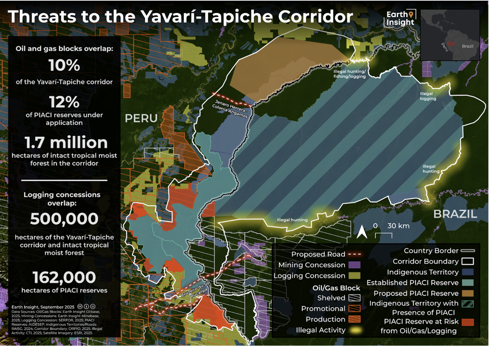
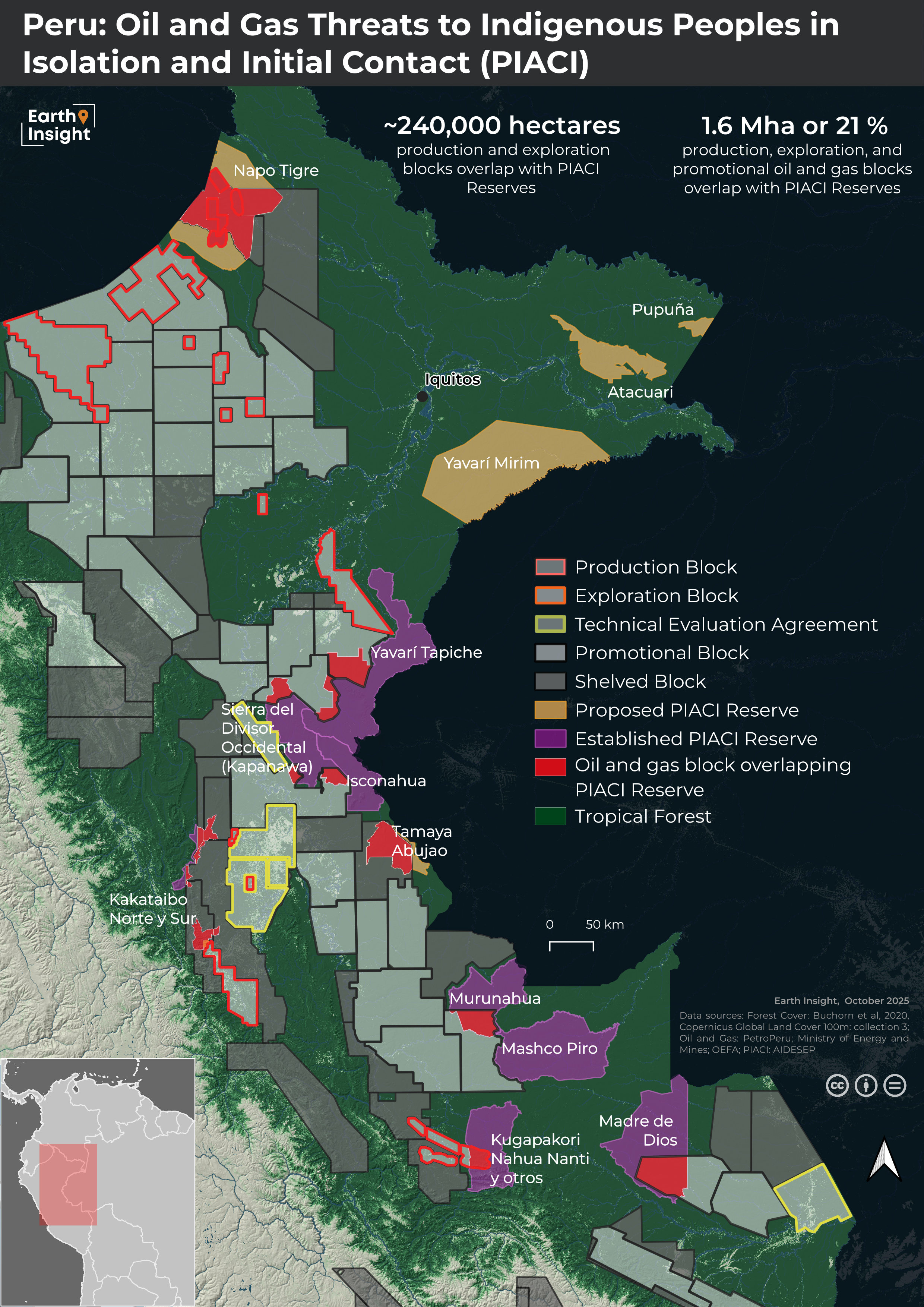
In Peru, as mapping shows in a threat report and below, oil and gas blocks overlap with 21% of existing and proposed PIACI reserves (which could be a primary motivation behind repeated attempts to annul PIACI reserves by far-right members of parliament).
The Global Movement for Fossil Free Exclusion Zones
As the maps and analysis above illustrate, there is a real need to ensure that oil and gas and other extractive concessions are removed from high-integrity forests, Indigenous Peoples’ territories, and local communities’ lands.
View from Tambopata, Perú. Image credit: Edwin Bellota
COP 30 represents a tremendous opportunity to remove oil and gas expansion threats to champion this cause. There is momentum coming out of the 2025 IUCN World Conservation Congress, which recognised the lack of policies that address the impacts of fossil fuel extraction, and leading towards the First International Conference for the Phase-Out of Fossil Fuels taking place in Colombia next April.
Leading nations that are endorsing the Fossil Fuel Non-Proliferation Treaty and joining the Beyond Oil and Gas Alliance have an opportunity to work together to ensure the transition away from fossil fuels also protects tropical forests and Indigenous Peoples’ territories.
This growing momentum for fossil-free forests is vital as are broader efforts to address other extractive pressures and deforestation drivers.
Methodology
Data Disclaimer:
The geospatial analyses in this report are an attempt to capture threats to Tropical Moist Forest areas using the most recently available, most accurate and precise data and methods available. As such, the results of these analyses may change between reports as data and/or methods are updated. Earth Insight takes a precautionary approach to estimating the potential area under oil and gas threats. Oil and gas data used in the analyses in this report include active production blocks as well areas under multiple stages of exploration and permitting. This approach provides the most expansive view of areas under threat of extractive industries.
These maps and analyses are based on results from Closing Window (Earth Insight et al. 2024). The oil and gas dataset used to calculate overlaps with intact forest and shown on the maps was last updated in August 2024, and therefore does not include new developments in the DRC, Indonesia, Peru, among other countries. Additionally, tropical forest cover data does not reflect the most recent changes.
Oil and Gas Blocks
The extent of oil and gas blocks was compiled by Earth Insight based on recent official publications by the Ministries of Natural Resources or Energy and the national petroleum companies of Brazil, Bolivia, Peru, Ecuador, Colombia, Venezuela, Guyana, Suriname, Democratic Republic of Congo, Republic of Congo, Central African Republic, Gabon, Cameroon, Equatorial Guinea, Brunei, Cambodia, Indonesia, Malaysia, Myanmar, Papua New Guinea, Philippines, Thailand, and Vietnam.
Blocks that are offshore were removed from analytical layers. To account for overlapping oil and gas blocks, particularly in Indonesia, areas of overlap were removed to avoid double-counting threats.
Oil and Gas Threats to Forest Analysis
The tropical moist forest cover area under oil and gas blocks was calculated by intersecting the Undisturbed forest class pixels from the JRC Tropical Moist Forest (TMF) cover product (Vancutsem et al., 2021) with the oil and gas layer using Zonal Histogram, and then summarizing the number of pixels by country. The Copernicus Global Land Service, derived from the PROBA-V satellite, was used for visualization (Buchhorn et al., 2020).
Data Sources
Oil and gas blocks: Amazon: RAISG oil and gas block database (2023), Bolivian Ministry of Hydrocarbons and Energy, Brazilian National Agency of Petroleum and Natural Gas and Biofuels, Colombian National Hydrocarbon Agency, Ecuadorian Ministry of Energy and NonRenewable Resources, Guyanese Ministry of Natural Resources, PerúPetro, Staatsolie, Venezuela’s Ministry of Energy and Petroleum. Congo: Ministry of Mines, Industry and Technological Development of Cameroon, Ministry of Energy, Mines, Geology and Water Resources of the Central African Republic, Ministry of Hydrocarbons of the Democratic Republic of Congo, Ministry of Mines and Hydrocarbons of Equatorial Guinea, Ministry of Hydrocarbons of the Republic of Congo, the Ministry of Oil, Gas and Hydrocarbons of Gabon. Southeast Asia: Cambodian National Petroleum Authority, Indonesian Ministry of Energy and Mineral Resources, Department of Energy of the Philippines, PetroVietnam Exploration and Production Company (PVEP), Thai Ministry of Energy, Petronas (Malaysia), Ministry of Energy of Myanmar, Papua New Guinea Department of Petroleum and Energy.
Tropical Moist Forest: C. Vancutsem, F. Achard, J.-F. Pekel, G. Vieilledent, S. Carboni, D. Simonetti, J. Gallego, L.E.O.C. Aragão, R. Nasi. (2021). Long-term (1990-2019) monitoring of forest cover changes in the humid tropics. Science Advances
Tree Cover Fraction: Buchhorn, M.; Smets, B.; Bertels, L.; Lesiv, M.; Tsendbazar, N.-E.; Masiliunas, D.; Linlin, L.; Herold, M.; Fritz, S. (2020). Copernicus Global Land Service: Land Cover 100m: Collection 3: epoch
2019: Globe (Version V3.0.1) [Data set]. Zenodo. DOI: 10.5281/zenodo.3939050